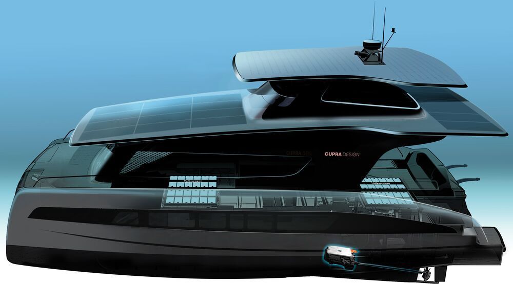
Toggle light / dark theme

Turbulence is everywhere—it rattles our planes and makes tiny whirlpools in our bathtubs—but it is one of the least understood phenomena in classical physics.

Turbulence occurs when an ordered fluid flow breaks into small vortices, which interact with each other and break into even smaller vortices, which interact with each other and so-on, becoming the chaotic maelstrom of disorder that makes white water rafting so much fun.

But the mechanics of that descent into chaos have puzzled scientists for centuries.

WASHINGTON — SpaceX is proposing a significant increase in launch activity in Florida over the next few years, including missions to polar orbits and those that will require the use of a new vertical payload integration tower.

The Federal Aviation Administration’s Office of Commercial Space Transportation published a draft environmental assessment Feb. 27 regarding SpaceX launch activities from both Launch Complex 39A at the Kennedy Space Center and Space Launch Complex 40 at neighboring Cape Canaveral Air Force Station. The assessment, the FAA said, will be used in new or modified commercial launch licenses for Falcon 9 and Falcon Heavy vehicles from those sites.

One reason for the assessment, the report states, is “SpaceX’s launch manifest includes more annual Falcon launches and Dragon reentries than were considered in previous [environmental] analyses.” SpaceX performed 11 launches from LC-39A and SLC-40 in 2019 and 15 in 2018, the most any one year to date.

In an attempt to reduce traffic jams, Luxembourg has become the first country in the world to make all public transport free from February 29. This is the first time that the decision to offer free public transport has covered an entire country, the transport ministry said.

The decision has been observed in Luxembourg so as to bring down the congestion on streets, AFP reports. As a result of this decision, every person will be able to save around 100 euros ($110) per year.

The free public transport system, however, does not include first-class travel tickets on trains and certain night bus services.

Do you àgree?


In Peter Diamandis and Steven Kotler’s new book, The Future Is Faster Than You Think, the futurist and science writer talk about converge and how a host of technologies, including VR, quantum computing, and A.I., are speeding up development of flying cars and changing new and old industries.

Astra and the Defense Advanced Research Projects Agency (DARPA) are readying for the first launch in a dual-mission “launch challenge”. Astra, the launch contractor, is currently conducting final preparations ahead of the launch of their Rocket 3.0 vehicle, nicknamed “1 of 3”. Both missions will launch from the Pacific Spaceport Complex – Alaska (PSCA) in Kodiak, Alaska. The first launch attempt is scheduled for 3:30 PM ET on February 27. The window stretches until March 1.

Astra and the DARPA launch challenge

Thursday’s launch will be the third for Astra, coming after two launches in July and November 2018. Both launched from the PSCA in Alaska. These were originally believed to be failures. However, Astra stated that the first was successful, and the second was only “shorter than planned”. Neither were designed to reach orbit, as they didn’t have functioning second stages.

Archaeologists have used laser technology to map a 100-km (62-mile) Maya stone road that could have been built 1,300 years ago to help with the invasion of an isolated city in modern-day Mexico. The ancient highway is thought to have been constructed at the command of the warrior queen Lady K’awiil Ajaw, and would have been coated in white plaster.

The 26 ft (8 m)-wide road, also known as Sacbe 1 or White Road 1, stretches from the ancient city of Cobá – one of the greatest cities of the Maya world – to the distant, smaller settlement of Yaxuná, located in the Yucatan Peninsula.

Newly-published research has shed new light on the nature of Lady K’awiil Ajaw’s great road by making use of light detection and ranging, otherwise known as LiDAR technology. To take their measurements, the authors made use of an airborne LiDAR instrument, which beamed lasers at the surface as it passed over the ancient road.