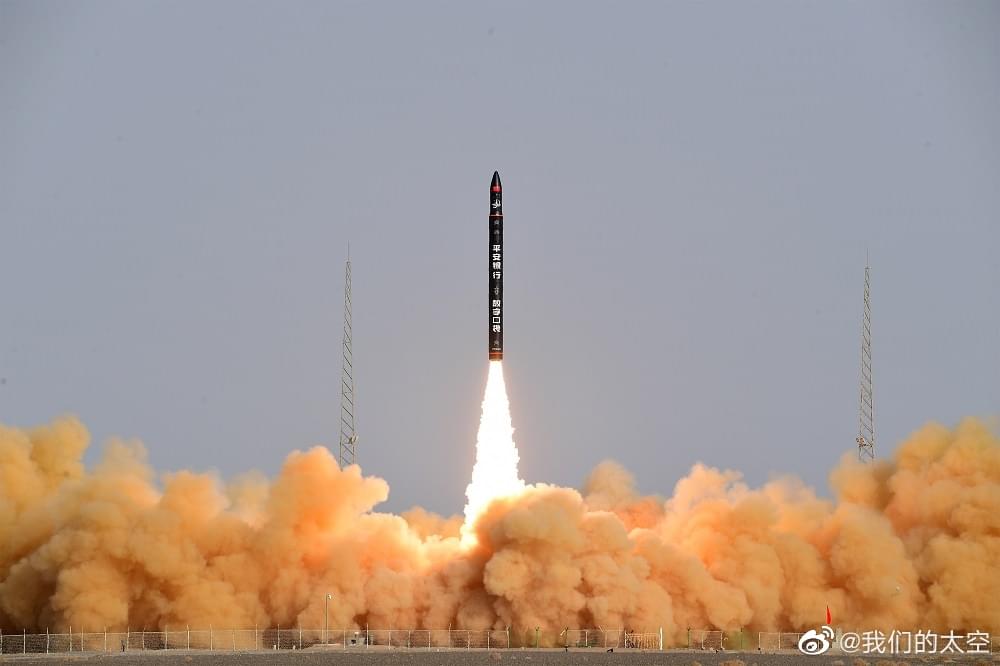
Menu

Blog

Archive for the ‘satellites’ category: Page 108

Apr 24, 2020

Elon Musk says Starlink internet private beta to begin in roughly three months, public beta in six

Posted by in categories: Elon Musk, internet, satellites

SpaceX CEO and founder Elon Musk has shared more details about when in 2020 we can expect the company’s Starlink low-latency, high-bandwidth satellite internet service to actually be available to customers. He said on Twitter that a private beta for Starlink would begin in around three months, with a public beta to kick off roughly three months after that.

The initial beta test will apply to those located in “high latitudes,” Musk added. To date, SpaceX has said that Starlink service will initially be made available to customers in Canada and in the northern United States in 2020, with additional service expansion to follow to other parts of the world throughout 2021. On Twitter in response to a question about whether Germany counts as “high latitude,” Musk said that it does, indicating beta service at least may be available in more markets than the U.S. and Canada ahead of next year.

Late last year, Musk tweeted saying he was using a Starlink satellite connection to do so, and since then the company has launched six batches of 60 satellites each to build out its network. The small satellites work by flying around the Earth in low orbit, passing off connection between one another to ensure consistent service is provided to ground stations. They orbit lower than geostationary communications satellites, which provides latency and speed benefits, but don’t remain in a fixed position so a large number of them are required to provide consistent connectivity.

Apr 24, 2020

Scientists compile the first comprehensive geological map of the Moon

Posted by in category: satellites

Drawing on data from satellites and Apollo-era missions, scientists at the US Geological Survey (USGS), NASA and the Lunar Planetary Institute have pieced together what they say is the first comprehensive geological map of the Moon.

Our 4.5-billion-year-old satellite is adorned with all kinds of rocks, craters and other interesting geological features. To dig into the details, the scientists looked to regional maps from six Apollo missions and combined these with modern data from recent satellite missions.

Refreshing the historical maps with fresh scientific observations enabled the scientists to put together an incredibly detailed perspective of the Moon, showing its geology at a scale of 1:5,000,000.

Apr 23, 2020

SpaceX’s Starlink network surpasses 400-satellite mark after successful launch

Posted by in categories: futurism, satellites

After years of studies, test-firings and a survey of U.S. industry in preparation for launch of a Mars Sample Return mission in 2026, NASA has settled on a solid-fueled design for a miniature rocket with a first-of-its-kind purpose: Launching a payload from Mars for a trip back to Earth.

The small launcher is called a Mars Ascent Vehicle, or MAV. The MAV will play a key role in the Mars Sample Return mission being developed by NASA and the European Space Agency.

Continue reading “SpaceX’s Starlink network surpasses 400-satellite mark after successful launch” »

Apr 22, 2020

Starlink Mission

Posted by in category: satellites

SpaceX is targeting Wednesday, April 22 at 3:30 p.m. EDT, or 19:30 p.m. UTC, for its seventh launch of Starlink satellites. Falcon 9 will lift off from Launch Complex 39A (LC-39A) at NASA’s Kennedy Space Center in Florida. A backup opportunity is available on Thursday, April 23 at 3:15 p.m. EDT, or 19:15 UTC.

Falcon 9’s first stage previously supported Crew Dragon’s first flight to the International Space Station, launch of the RADARSAT Constellation Mission, and the fourth Starlink mission. Following stage separation, SpaceX will land Falcon 9’s first stage on the “Of Course I Still Love You” droneship, which will be stationed in the Atlantic Ocean. Falcon 9’s fairing previously supported the AMOS-17 mission.

Apr 22, 2020

Dengue case predictor mapping system wins the 2019 NASA global hackathon

Posted by in categories: astronomy, big data, computing, disruptive technology, environmental, events, hacking, information science, innovation, machine learning, mapping, open source, satellites, science, software, space
Upper row Associate American Corner librarian Donna Lyn G. Labangon, Space Apps global leader Dr. Paula S. Bontempi, former DICT Usec. Monchito B. Ibrahim, Animo Labs executive director Mr. Federico C. Gonzalez, DOST-PCIEERD deputy executive director Engr. Raul C. Sabularse, PLDT Enterprise Core Business Solutions vice president and head Joseph Ian G. Gendrano, lead organizer Michael Lance M. Domagas, and Animo Labs program manager Junnell E. Guia. Lower row Dominic Vincent D. Ligot, Frances Claire Tayco, Mark Toledo, and Jansen Dumaliang Lopez of Aedes project.

MANILA, Philippines — A dengue case forecasting system using space data made by Philippine developers won the 2019 National Aeronautics and Space Administration’s International Space Apps Challenge. Over 29,000 participating globally in 71 countries, this solution made it as one of the six winners in the best use of data, the solution that best makes space data accessible, or leverages it to a unique application.

Dengue fever is a viral, infectious tropical disease spread primarily by Aedes aegypti female mosquitoes. With 271,480 cases resulting in 1,107 deaths reported from January 1 to August 31, 2019 by the World Health Organization, Dominic Vincent D. Ligot, Mark Toledo, Frances Claire Tayco, and Jansen Dumaliang Lopez from CirroLytix developed a forecasting model of dengue cases using climate and digital data, and pinpointing possible hotspots from satellite data.

Sentinel-2 Copernicus and Landsat 8 satellite data used to reveal potential dengue hotspots.

Correlating information from Sentinel-2 Copernicus and Landsat 8 satellites, climate data from the Philippine Atmospheric, Geophysical and Astronomical Services Administration of the Department of Science and Technology (DOST-PAGASA) and trends from Google search engines, potential dengue hotspots will be shown in a web interface.

Using satellite spectral bands like green, red, and near-infrared (NIR), indices like Fraction of Absorbed Photosynthetically Active Radiation (FAPAR) and Normalized Difference Vegetation Index (NDVI) are calculated in identifying areas with green vegetation while Normalized Difference Water Index (NDWI) identifies areas with water. Combining these indices reveal potential areas of stagnant water capable of being breeding grounds for mosquitoes, extracted as coordinates through a free and open-source cross-platform desktop geographic information system QGIS.

Check out the website here: http://aedesproject.org/

Winners visit the Philippine Earth Data Resource and Observation (PEDRO) Center at the DOST-Advanced Science and Technology Institute in Diliman, Quezon City with Dr. Joel Joseph S. Marciano, Jr.

Apr 21, 2020

Scientists Explore Underwater Quantum Links for Submarines

Posted by in categories: encryption, internet, quantum physics, satellites

:oooo.


Underwater quantum links are possible across 30 meters (100 feet) of turbulent water, scientists have shown. Such findings could help to one day secure quantum communications for submarines.

Quantum cryptography exploits the quantum properties of particles such as photons to help encrypt and decrypt messages in a theoretically unhackable way. Scientists worldwide are now endeavoring to develop satellite-based quantum communications networks for a global real-time quantum Internet.

Continue reading “Scientists Explore Underwater Quantum Links for Submarines” »

Apr 18, 2020

Parasitic Spacecraft Docks With Dead Satellite, Brings It Back to Life

Posted by in category: satellites

The old satellite just got brought back from the dead.

Apr 16, 2020

The Sun Is Spitting Out Strange Patterns of Gamma Rays—and No One Knows Why

Posted by in categories: climatology, particle physics, satellites, sustainability

Scientists have studied this ebb and flow for centuries, but only began understanding its effects on our planet at the dawn of the space age in the mid-20th century. Now it is clear that around solar maximum the sun is more likely to bombard Earth with charged particles that damage satellites and power grids. The solar cycle also plays a minor role in climate, as variations in irradiance can cause slight changes in average sea-surface temperatures and precipitation patterns. Thus, a better understanding of the cycle’s physical drivers is important for sustainable living on Earth.

Yet scientists still lack a model that perfectly predicts the cycle’s key details, such as the exact duration and strength of each phase. “I think the solar cycle is so stable and clear that there is something fundamental that we are missing,” says Ofer Cohen, a solar physicist at the University of Massachusetts Lowell. One obstacle to figuring it out, he says, is that crucial details of the apparent mechanisms behind the cycle—such as the sun’s magnetic field—are largely hidden from our view. But that might be about to change.

Tim Linden, an astronomer at The Ohio State University, and his colleagues recently mapped how the sun’s high-energy glow dances across its face over time. They found a potential link between these high-energy emissions, the sun’s fluctuating magnetic field and the timing of the solar cycle. This, many experts argue, could open a new window into the inner workings of our nearest, most familiar star.

Apr 16, 2020

Space and Missile Systems Center awards $35 million Space Test Program

Posted by in categories: futurism, satellites

The U.S. Space Force’s Rocket Systems Launch Program (RSLP) Office at Kirtland Air Force Base, Albuquerque, New Mexico, part of the Space and Missile Systems Center’s Launch Enterprise, today awarded a $35 million task order to VOX Space, LLC of El Segundo, California, for the Space Test Program-S28 (STP-S28) launch service. This is the first task order under the Orbital Services Program-4 (OSP-4) Indefinite Delivery/Indefinite Quantity (IDIQ) contract.

STP-S28 is a complex mission that will deliver a number of technology demonstrations to orbit, such as Space Domain Awareness and communications advancement, and inform future space system development.

VOX Space, a U.S.-incorporated, wholly-owned subsidiary of Virgin Orbit, LLC, will utilize three launches of the LauncherOne rocket to deliver 44 small satellites to low earth orbit. The first launch is tentatively planned for October 2021.

Apr 16, 2020

Russia conducts another test of its missile system to take out satellites

Posted by in categories: military, satellites

ASAT tests are also widely condemned by many in the space community, as these demonstrations typically create hundreds to thousands of pieces of debris that can last for months, and even years, in orbit. Because these tests are high speed and high impact, the resulting debris can spread far and wide. Those pieces then pose a threat to other functioning spacecraft. A fast-moving piece of junk can render an operational satellite inoperable if they hit head on.


Today, Russia conducted another test of its missile system designed to destroy a satellite in orbit around Earth, according to US Space Command. It is believed to be the 10th test of this anti-satellite, or ASAT, technology, but it’s unclear if the missile actually destroyed anything in space.

Regardless of its target, US Space Command is openly condemning the demonstration. “Russia’s [anti-satellite] test provides yet another example that the threats to US and allied space systems are real, serious, and growing,” Gen. John Raymond, commander of USSPACECOM and the US Space Force chief of space operations, said in a statement. “The United States is ready and committed to deterring aggression and defending the Nation, our allies and U.S. interests from hostile acts in space.”

Continue reading “Russia conducts another test of its missile system to take out satellites” »