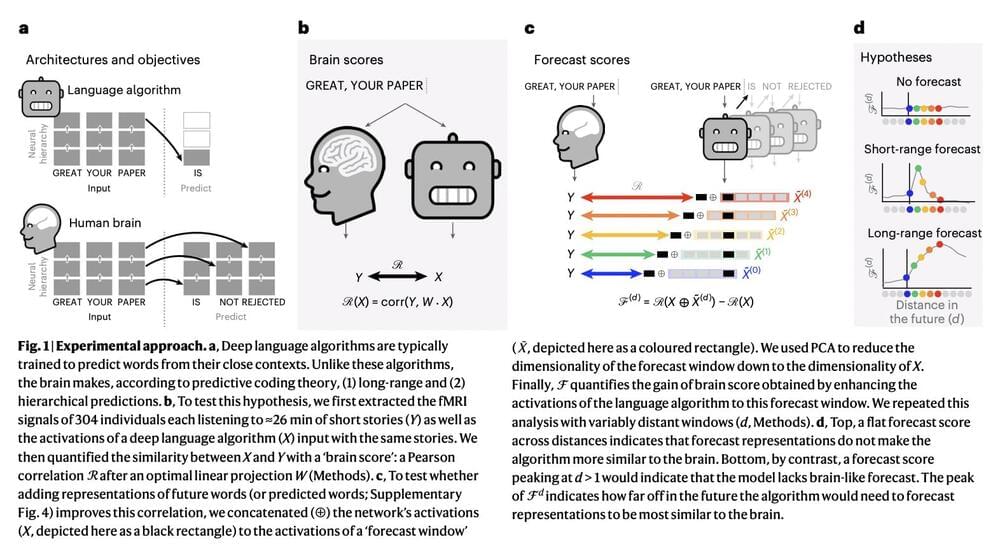
Toggle light / dark theme

Navigating and mapping rivers has long been a central component in human exploration. Whether it was Powell exploring the Colorado’s canyons or Pizarro using the Amazon to try to find El Dorado, rivers, and our exploration of them, have been extremely important. Now, scientists have mapped out an entirely new, unique river basin. This one happens to be on an entirely different planet, and dried up billions of years ago.

Three to four billion years ago, Mars did in fact have running rivers of water. Evidence for these rivers has shown up in satellite imagery and rover samples for almost as long as we have been exploring the red planet. Since Mars has little tectonics or erosion, that evidence has remained somewhat intact until the present day.

Recently, a team of scientists developed a tool to better examine those features. They managed to stitch together an 8-trillion pixel image of the entire Martian surface. Each pixel in this incredibly detailed image represents about a 5–6 square meter area. Unfortunately, it also doesn’t seem to available to the general public just year. Whether it is or not it is sure to prove useful for a variety of research projects regarding the environment of Mars. One of the first ones, which was recently published a paper in Geology was a map of the red planet’s river “ridges”.

CSIRO has made a detailed radio survey of the southern hemisphere, and discovered a million new galaxies.


Although radio astronomy has been around since the 1930s, it is only in recent years that astronomers have been able to make high-resolution maps of the radio sky. Sky maps are difficult for radio telescopes because radio antennas need to be focused on an extremely small patch of sky to capture images in high resolution. But with modern antennas and computer processing, we can now scan the sky quickly enough to map the heavens in a reasonable amount of time.

In the northern hemisphere, the most detailed radio sky maps have been done by the Very Large Array (VLA). In the 1990s the VLA made the first full-sky surveys of the northern sky. After its upgrade in the 2000s, the observatory began the VLA Sky Survey (VLASS), which has mapped nearly 10 million radio sources.

The location of the VLA lets it observe about 80% of the sky, but it cannot see the southern sky very well. For that, you’d need a radio observatory in the southern hemisphere. Fortunately, there is now a powerful radio telescope array in Australia, and it has recently made a detailed radio map.

DroneSeed will be allowed to operates drones beyond visual line of sight.


DroneSeed, a company that uses fleets of drones to reforest areas burned in wildfires, received approval in October from the Federal Aviation Administration (FAA) for its heavy-lift drones to operate Beyond Visual Line of Sight (BVLOS) and to expand its use of heavy-lift drone swarms to California, Colorado, Montana, Nevada, Arizona and New Mexico.

The FAA’s action allows DroneSeed to begin reforesting once a fire is contained and airspace is clear. Their aircraft drop seeds that are encapsulated in vessels consisting of four to six seeds, fertilizer, natural pest deterrents, and fibrous material which absorbs water and increases survivability.

The company has designed a system around a swarm of drones that can drop tree seeds in places where they have a decent chance of survival. First they survey the area with a drone using lidar and a multispectral camera to map the terrain and the vegetation. Software then identifies areas with invasive species or other plants the landowner wants to eliminate that could compete with the new trees. Then a drone can apply herbicide to only the patches that need it, rather than dumping pesticide over the entire landscape. The next step is to use artificial intelligence to sort through the mapping data to find areas where a dropped seed is most likely to germinate, in order to avoid, for example, rock, roads, and unburned locations. After the aircraft is launched, it operates autonomously flying a grid pattern with five drones.

“People want to know what makes someone a good programmer,” Liu said. “If we know what kind of neuro mechanisms are activated when someone is programming, we might be able to find a better training program for programmers.” By mapping the brain activity of expert computer programmers while they puzzled over code, Johns Hopkins University scientists have found the neural mechanics behind this increasingly vital skill.

Though researchers have long suspected the for computer programming would be similar to that for math or even language, this study revealed that when seasoned coders work, most happens in the network responsible for logical reasoning, though in the left brain region, which is favored by language.

“Because there are so many ways people learn programming, everything from do-it-yourself tutorials to formal courses, it’s surprising that we find such a consistent brain activation pattern across people who code,” said lead author Yun-Fei Liu, a Ph.D. student in the university’s Neuroplasticity and Development Lab. “It’s especially surprising because we know there seems to be a crucial period that usually terminates in for , but many people learn to code as adults.”

A new tool that uses light to map out the electronic structures of crystals could reveal the capabilities of emerging quantum materials and pave the way for advanced energy technologies and quantum computers, according to researchers at the University of Michigan, University of Regensburg and University of Marburg.

A paper on the work is published in Science.

Applications include LED lights, solar cells and artificial photosynthesis.

Radar and LiDAR have been incredibly quick and effective tools for mapping and surveying the Earth’s surface from aircraft and satellites, but while they can deliver accurate readings through cloud and even forest canopy cover, they can’t tell you what’s below the surface of the sea. Seawater absorbs far too much of the signal.

Sonar remains the most effective way to map out the sea floor – but the vast majority of the oceans that form 70 percent of the Earth’s surface remain unmapped, because sonic waves have hitherto only been able to be sent out from underwater. Sound waves sent from air into water lose more than 99.9 percent of their energy in the translation; it’s why the outside world goes so wonderfully silent when you dive down to the bottom of the pool. The meagre remaining 0.1 percent of the energy does create a sonar signal, but that loses a further 99.9 percent of its energy upon coming back up from the water into the air.

Sonar is commonly used for submarine detection, among other things, by military forces the world over, chiefly using devices on the undersides of ships. But the closest things thus far to an airborne sonar system are “dippers” like Thales’ FLASH system; low-frequency, wide-band sonar systems that dangle from cables out the bottom of helicopters and dip into the sea below like noisy teabags. These methods are slow, expensive, and no good at covering large areas.

Drone privacy laws vary all around the world — and what might get you a great shot in one country could get you jail time in another.


Surfshark, a digital security firm, introduces Mapped: The state of drone privacy laws in (nearly) every country.

Drone privacy is serious business – and what gets you a great image in one country could get you a jail term in another. Finding these laws, however, is hit or miss – so this new research from Surfshark is a great place to start for world travelers.

Excerpts from the Red Folder.


If we had a “Physics paper title of the year award”, the 2020 winner would surely have to be “The arches of chaos in the solar system”, which was published this week in Science Advances by Nataša Todorović, Di Wu and Aaron Rosengren. In their paper, the trio “reveal a notable and hitherto undetected ornamental structure of manifolds, connected in a series of arches that spread from the asteroid belt to Uranus and beyond”. These manifolds are structures that arise from the gravitational interactions between the Sun and planets. They play an important role in spacecraft navigation and also explain the erratic nature of comets.

The paper is beautifully written, describing the manifolds as “a true celestial autobahn,” and going on to say that they “enable ‘Le Petit Prince’ grand tour of the solar system”. And if that has not piqued your curiosity, the figures are wonderful as well – with the above image being “Jovian-minimum-distance maps for the Greek and Trojan orbital configurations”.

The luxury watchmaker Bremont has released the Hawking Limited Edition watch that contains bits of a wooden desk once used by the late Stephen Hawking. The “exquisite chromometer” also contains pieces of a meteorite and is etched with a view of the night sky as seen from Oxford on 8 January 1942, Hawking’s place and date of birth. What is more, the serial number of the watch is printed on paper from a 1979 paper by Hawking that was cowritten by Gary Gibbons.