Scientists at Pacific Northwest Research Institute (PNRI) have overturned a long-held belief in genetics: that inheriting two harmful variants of the same gene always worsens disease. Instead, the team found that in many cases, two harmful variants can actually restore normal protein function.
Their work appears in the Proceedings of the National Academy of Sciences.
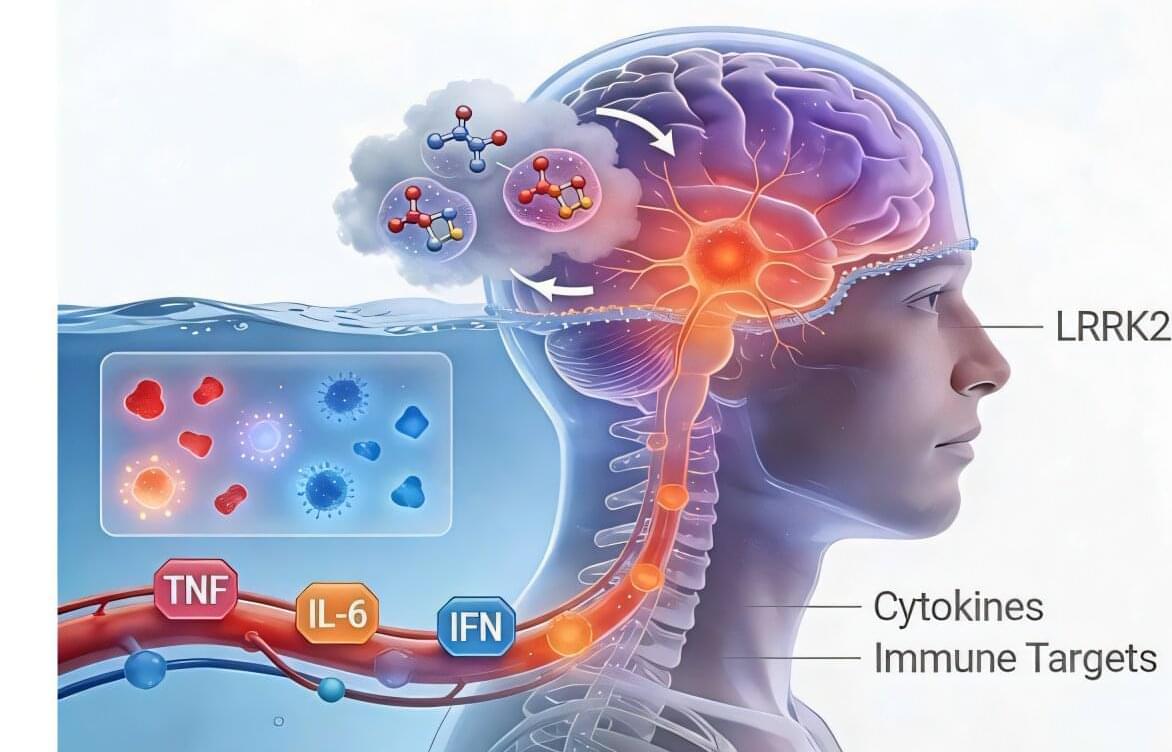
Parkinson’s disease (PD) is a debilitating and progressive neurodegenerative disorder caused by the loss of dopamine-producing neurons in the substantia nigra, a brain region essential for motor control. Clinically, it is marked by tremor, rigidity, bradykinesia and postural instability, symptoms that progressively erode independence and quality of life.
PD affects millions of people worldwide, including nearly one million individuals in the United States, making it one of the fastest-growing neurological disorders. In the U.S. alone, the disease imposes a profound health care and socioeconomic burden, with annual costs reaching tens of billions of dollars due to medical care, lost productivity and long-term disability.
While environmental factors contribute to disease risk, genetic drivers are increasingly recognized, with mutations in the leucine-rich repeat kinase 2 (LRRK2) gene representing one of the most common causes of both familial and sporadic PD. Understanding how LRRK2 mutations drive disease is therefore central to developing therapies that go beyond symptoms control.
A new study from Karolinska Institutet, published in Nature Communications, reveals how rhythmic brain waves known as alpha oscillations help us distinguish between our own body and the external world. The findings offer new insights into how the brain integrates sensory signals to create a coherent sense of bodily self.
What makes you feel that your hand is yours? It might seem obvious, but the brain’s ability to tell self from non-self is a complex process.
Using a combination of behavioral experiments, brain recordings (EEG), brain stimulation, and computational modeling with a total of 106 participants, researchers from Karolinska Institutet investigated how the brain combines visual and tactile signals to create the feeling that a body part belongs to oneself—a phenomenon known as the sense of body ownership.
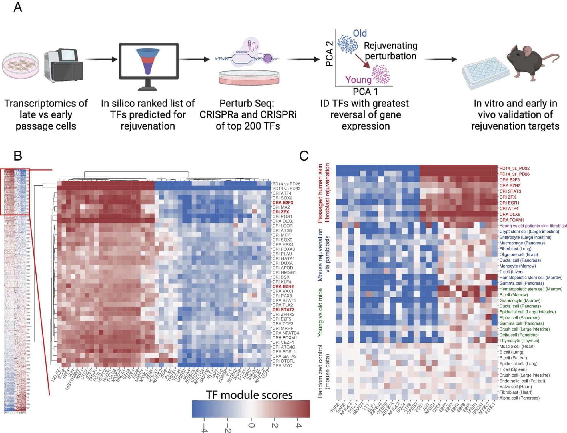
As we age, we don’t recover from injury or illness like we did when we were young. But new research from UCSF has found gene regulators—proteins that turn genes on and off—that could restore the aging body’s ability to self-repair.
The scientists looked at fibroblasts, which build the scaffolding between cells that give shape and structure to our organs.
Fibroblasts maintain this scaffolding in the face of normal wear, disease, and injury. But over time, they slow down, and the body suffers.
In this quality improvement project, nonmydriatic ocular fundus imaging enabled prompt and accurate rule-out of papilledema in patients with headaches presenting to the emergency department and facilitated rapid and reliable examination of the ocular fundus.
Huang made his feelings about AI skeptics, haters, and doom-mongers clear on a recent episode of the No Priors podcast.
The boss of the world’s most valuable company said “the battle of the narratives” between those who think AI will benefit society and those who believe it will degrade or even destroy it was one of his biggest takeaways from 2025.
Huang did admit that “it’s too simplistic” to dismiss either of these views entirely, but he believes some naysayers’ views are having a detrimental effect.
This video explores aliens, mind uploading to other species, genetic engineering, and future robots.
SOURCES: • https://en.wikipedia.org/wiki/Eagle_eye#:~… https://www.scientificamerican.com/ar… • https://en.wikipedia.org/wiki/Human_c… ___ 💡 Future Business Tech explores the future of technology and the world. Examples of topics I cover include: • Artificial Intelligence & Robotics • Virtual and Augmented Reality • Brain-Computer Interfaces • Transhumanism • Genetic Engineering SUBSCRIBE: https://bit.ly/3geLDGO ___ This video explores the future of ChatGPT and 10 ways it could change society. Other related terms: aliens, alien species, advanced civilization, genetic engineering, robot, mind upload, mind uploading, brain computer interface, artificial intelligence, ai, future business tech, future technology, future technologies, etc. ℹ️ Some links are affiliate links. They cost you nothing extra but help support the channel so I can create more videos like this. #alien #aliens #avatar #avatar2 #geneticengineering #braincomputerinterface. • https://vcahospitals.com/know-your-pe… • https://www.scientificamerican.com/ar… • https://en.wikipedia.org/wiki/Human_c…
💡 Future Business Tech explores the future of technology and the world.
Examples of topics I cover include: • Artificial Intelligence & Robotics. • Virtual and Augmented Reality. • Brain-Computer Interfaces. • Transhumanism. • Genetic Engineering.
This video explores the future of ChatGPT and 10 ways it could change society. Other related terms: aliens, alien species, advanced civilization, genetic engineering, robot, mind upload, mind uploading, brain computer interface, artificial intelligence, ai, future business tech, future technology, future technologies, etc.
Dartmouth researchers conducted the first-ever clinical trial of a generative AI-powered therapy chatbot and found that the software resulted in significant improvements in participants’ symptoms, according to results published March 27 in NEJM AI.
People in the study also reported they could trust and communicate with the system, known as Therabot, to a degree that is comparable to working with a mental health professional.
The trial consisted of 106 people from across the United States diagnosed with major depressive disorder, generalized anxiety disorder, or an eating disorder. Participants interacted with Therabot through a smartphone app by typing out responses to prompts about how they were feeling or initiating conversations when they needed to talk.
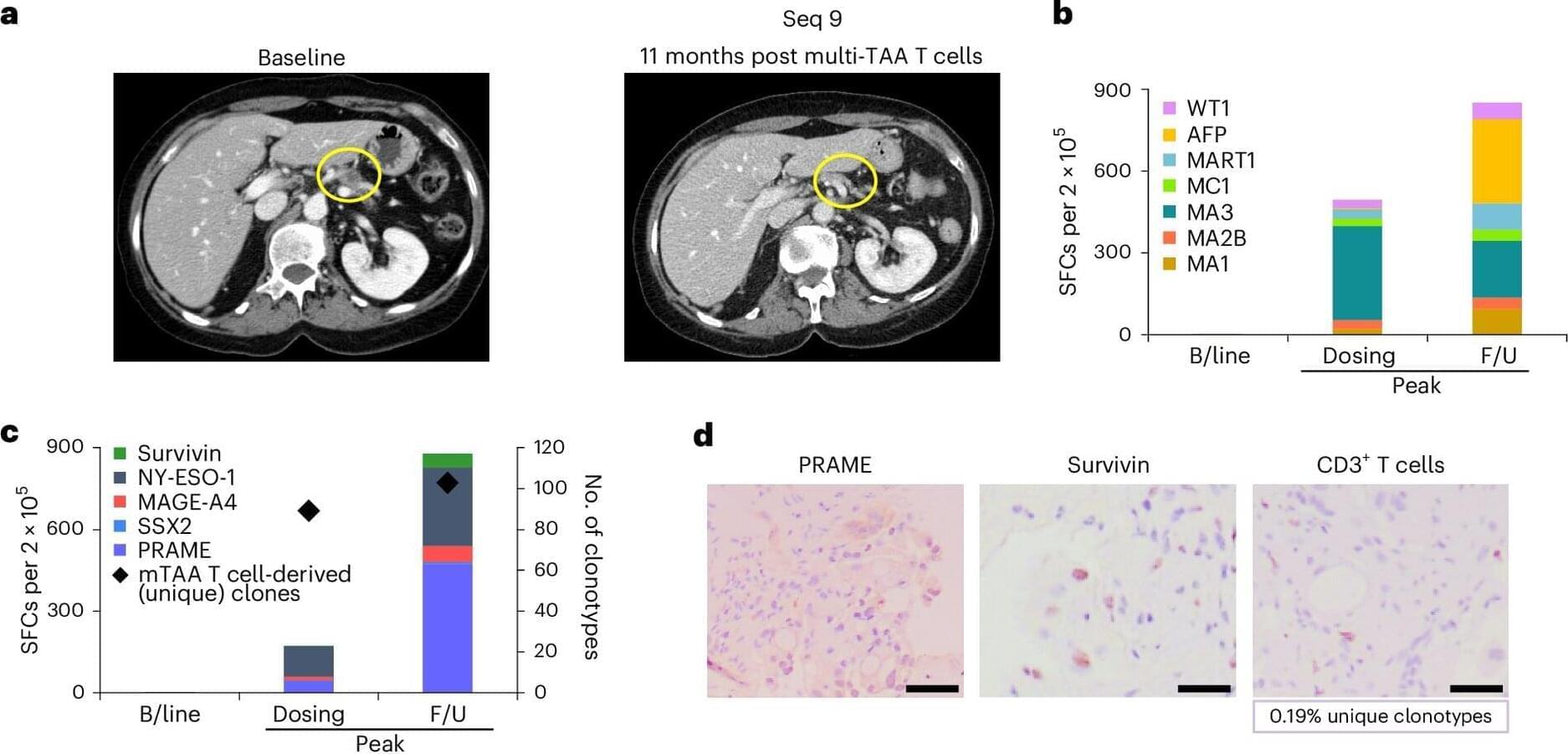
A recent publication in Nature Medicinedescribes a novel immunotherapy targeting pancreatic cancer that has shown promising results in a first in-human phase 1/2 trial.
The TACTOPS trial, which investigated the safety and clinical effects of autologous T cell therapy targeting multiple tumor antigens, was a collaboration among researchers at Baylor College of Medicine, the Dan L Duncan Comprehensive Cancer Center, the Center for Cell and Gene Therapy, Texas Children’s Hospital and Houston Methodist Hospital.
“We wanted to develop a targeted therapeutic that would hone the immune system on tumor-associated antigens (TAAs) that were present on malignant cells. We targeted five different antigens to deal with the polyclonal nature of the disease,” said co-corresponding author Dr. Ann Leen, professor of pediatrics–hematology and oncology in the Center for Cell and Gene Therapy.
