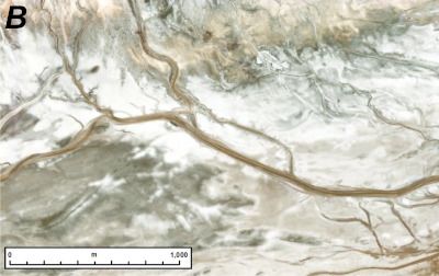
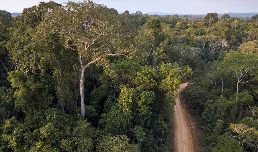
Toggle light / dark theme

New imaging method reveals HIV’s sugary shield in unprecedented detail

Scientists from Scripps Research and Los Alamos National Laboratory have devised a method for mapping in unprecedented detail the thickets of slippery sugar molecules that help shield HIV from the immune system.

Mapping these shields will give researchers a more complete understanding of why antibodies react to some spots on the virus but not others, and may shape the design of new vaccines that target the most vulnerable and accessible sites on HIV and other viruses.

The sugar molecules, or “glycans,” are loose and stringy, and function as shields because they are difficult for antibodies to grip and block access to the . The shields form on the outermost spike proteins of HIV and many other viruses, including SARS-CoV-2, the coronavirus that causes COVID-19, because these viruses have evolved sites on their spike proteins where glycan molecules—normally abundant in cells—will automatically attach.

Google Open-Sources 3D System That Shows How Places Looked in the Past

Head Image Caption: Street level view of 3D-reconstructed Chelsea, Manhattan

Historians and nostalgic residents alike take an interest in how cities were constructed and how they developed — and now there’s a tool for that. Google AI recently launched the open-source browser-based toolset “,” which was created to enable the exploration of city transitions from 1800 to 2000 virtually in a three-dimensional view.

Google AI says the name is pronounced as “re-turn” and derives its meaning from “reconstruction, research, recreation and remembering.” This scalable system runs on Google Cloud and Kubernetes and reconstructs cities from historical maps and photos.

Surviving Corona — A Warning: Facts, Fakery, and Hope for the Future

In this brief, at times controversial— even radical—volume. Dr. Ian C. Hale guides us through likely scenarios and gives us life-saving recommendations for effectively dealing with the next waves of the COVID-19 pandemic. This is a must read for public policy makers, medical professionals, and those mapping out their financial future in the post-corona world.

Autonomous Industrial Drones Now Fly Anywhere

There are four ways drones typically navigate. Either they use GPS or other beacons, or they accept guidance instructions from a computer, or they navigate off a stored map, or they are flown by an expert in control.

What do you when absolutely none of the four are possible?

You put AI on the drone and it flies itself with no outside source of data, no built-in mapping, and no operator in control.

Artificial intelligence algorithm can determine a neighborhood’s political leanings by its cars

From the understated opulence of a Bentley to the stalwart family minivan to the utilitarian pickup, Americans know that the car you drive is an outward statement of personality. You are what you drive, as the saying goes, and researchers at Stanford have just taken that maxim to a new level.

Using computer algorithms that can see and learn, they have analyzed millions of publicly available images on Google Street View. The researchers say they can use that knowledge to determine the political leanings of a given neighborhood just by looking at the cars on the streets.

“Using easily obtainable visual data, we can learn so much about our communities, on par with some information that takes billions of dollars to obtain via census surveys. More importantly, this research opens up more possibilities of virtually continuous study of our society using sometimes cheaply available visual data,” said Fei-Fei Li, an associate professor of computer science at Stanford and director of the Stanford Artificial Intelligence Lab and the Stanford Vision Lab, where the work was done.

Why Ford Wants Robot Dogs Running Through Its Plants

But Ford appears to have found a unique way to use a robot. We’ve seen some interesting applications for Boston Dynamics’ Spot robot, and the latest takes the 70-pound dog-like robot to the floors of a Ford transmission manufacturing plant.

These plants are reportedly so old — and have been re-tooled so many times — that Ford is unsure as to whether it possesses accurate floor plans. With an end goal of modernizing and retooling these plants, Ford is using Spot’s laser scanning and imaging technology to travel the plants so they can produce a detailed map.

According to TechCrunch, the manual facility mapping process is time-intensive, with lots of stops and starts as cameras are set up and repositioned station to station. By using two continuously roving robots, Ford can do the job in about half the time. The other benefit is Spot’s size: these little critters can access areas that humans can’t easily get to, and with five cameras they can sometimes provide a more complete picture of their surroundings.

/* */