Substack | https://domsniezka.substack.com/Twitter | https://twitter.com/domsniezkaWebsite | http://domsniezka.com/*****Michael Levin is a Scientist at Tufts…
Category: futurism – Page 224


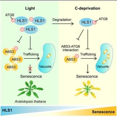
HLS1 interacts with ATG8 to negatively regulate the ABS3-mediated plant senescence pathway
Lei et al. show that HLS1 negatively regulates plant senescence and the ABS3-mediated senescence pathway by interacting with ATG8 and attenuating the ABS3-ATG8 interaction and the ability of ABS3 to promote senescence. Their study provides insights into the functional link between HLS1, ABS3, and ATG8 in plant senescence regulation.

New era of magnetization: Research sheds light on future applications in spintronics and valleytronics
Altermagnets, which exhibit momentum-dependent spin splitting without spin–orbit coupling (SOC) or net magnetization, have recently attracted significant international attention.
A team led by Prof. Liu Junwei from the Department of Physics at the Hong Kong University of Science and Technology (HKUST), along with their experimental collaborators, published their latest research findings in Nature Physics, which unveiled the first experimental observation of a two-dimensional layered room-temperature altermagnet, validating the theoretical predictions in Nature Communications made by Prof. Liu in 2021.
The realization and control of spin-polarized electronic states in solids are crucial for spintronics for encoding and processing information. Spin polarization is typically generated by coupling an electron’s spin to other degrees of freedom, such as orbital or magnetic moments.