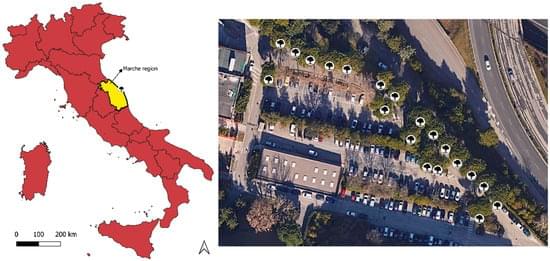
Due to ever-accelerating urbanization in recent decades, exploring the contributions of trees in mitigating atmospheric carbon in urban areas has become one of the paramount concerns. Remote sensing-based approaches have been primarily implemented to estimate the tree-stand atmospheric carbon stock (CS) for the trees in parks and streets. However, a convenient yet high-accuracy computation methodology is hardly available. This study introduces an approach that has been tested for a small urban area. A data fusion approach based on a three-dimensional (3D) computation methodology was applied to calibrate the individual tree CS. This photogrammetry-based technique employed an unmanned aerial vehicle (UAV) and spherical image data to compute the total height (H) and diameter at breast height (DBH) for each tree, consequently estimating the tree-stand CS.