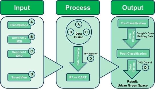
Jakarta holds the distinction of being the largest capital city among ASEAN countries and ranks as the second-largest metropolitan area in the world, following Tokyo. Despite numerous studies examining the diverse urban land use and land cover patterns within the city, the recent state of urban green spaces has not been adequately assessed and mapped precisely. Most previous studies have primarily focused on urban built-up areas and manmade structures. In this research, the first-ever detailed map of Jakarta’s urban green spaces as of 2023 was generated, with a resolution of three meters. This study employed a combination of supervised classification and evaluated two machine learning algorithms to achieve the highest accuracy possible.