Tourist spots in Paris, France… including Notre Dame. #NotreDame
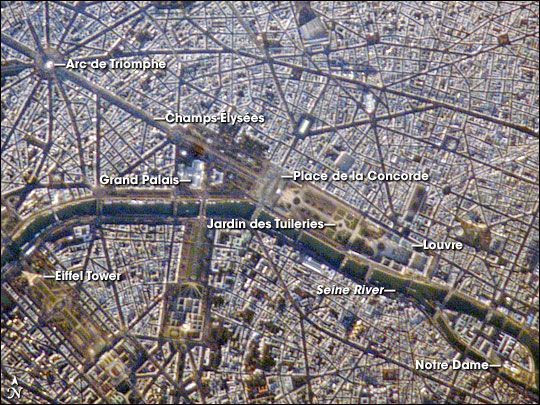
A crisp, clear winter day over France provided the International Space Station a detailed view of the city of Paris. This image, rotated and cropped from the original, shows the recognizable street pattern of the city—and some of the world’s most notable landmarks—along the Seine River. One of the main avenues radiating like spokes from the Arc de Triomphe (image upper left) is the Avenue des Champs-Élysées running southeast to the Garden of Tuileries (Jardin des Tuileries).
The garden—recognizable by its light green color relative to the surrounding built materials—was originally commissioned by Catherine de Medici in 1559, and is now bounded by the Place de la Concorde to the northeast and the Louvre museum along the Seine River at the southeast end. Other, similarly colored parks and greenspaces are visible throughout the image. Farther south on the Seine is the Íle de la Cité, location of the famous Notre Dame cathedral. Perhaps most prominent is the characteristic €œA € profile of the Eiffel Tower west of the Jardin des Tuileries, highlighted by morning sunlight.
Astronaut photograph ISS016-E-21564 was acquired on January 7, 2008 with a Kodak 760C digital camera fitted with a 800 mm lens, and is provided by the ISS Crew Earth Observations experiment. The image was taken by the Expedition 16 crew, and is provided by the Image Science & Analysis Laboratory, Johnson Space Center. The image in this article has been cropped and enhanced to improve contrast. Lens artifacts have been removed. The International Space Station Program supports the laboratory to help astronauts take pictures of Earth that will be of the greatest value to scientists and the public, and to make those images freely available on the Internet. Additional images taken by astronauts and cosmonauts can be viewed at the NASA/JSC Gateway to Astronaut Photography of Earth. Caption by Cynthia A Evans, NASA-JSC.
