“The presence of methane is critical to the existence of Titan’s atmosphere,” said Dr. Kelly Miller. “Scientists think an internal source must replenish the methane, or else the atmosphere has a geologically short lifetime.”
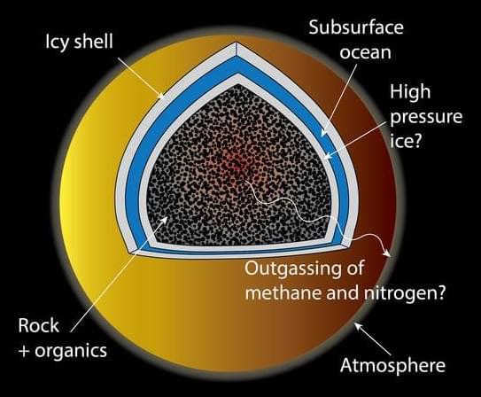
Saturn’s largest moon, Titan, is the only moon in the solar system with a dense atmosphere which is comprised of thick hazes of 95 percent nitrogen (N2) and 5 percent methane (NH4) that require radar instruments to see the moon’s surface. But what processes are responsible for keeping this thick atmosphere from escaping to space? This is what a recent study published in Geochimica et Cosmochimica Acta hopes to address as a team of researchers led by the Southwest Research Institute (SwRI) investigated how processes occurring in Titan’s interior could be fueling Titan’s atmosphere, specifically the methane.
“The presence of methane is critical to the existence of Titan’s atmosphere,” said Dr. Kelly Miller, who is a SwRI research scientist and lead author of the study. “The methane is removed by reactions caused by sunlight and would disappear in about 30 million years after which the atmosphere would freeze onto the surface. Scientists think an internal source must replenish the methane, or else the atmosphere has a geologically short lifetime.”
For the study, the researchers conducted a series of laboratory experiments with organic matter obtained from the Murchison meteorite to simulate conditions on Titan that could help explain how its atmosphere is replenished from the interior. In the end, the researchers found that temperatures above 250 degrees Celsius (482 degrees Fahrenheit) result in the methane production that is enough to replenish Titan’s atmosphere, along with enough nitrogen production to replenish the atmosphere, as well.


