Dr. Frank Marks, Director of the Hurricane Research Division, National Oceanic and Atmospheric Administration (NOAA), discussing improved forecasting technologies.
Ira Pastor, ideaXme life sciences ambassador and founder of Bioquark interviews Dr. Frank D. Marks, MS, ScD, Director of Hurricane Research Division, at NOAA.
Ira Pastor comments:
Weather and climate disasters affect the world’s population.
The total approximate cost of damages from weather and climate disasters in the U.S. alone from 1980 to 2019, is over $1.75 trillion, and a major component of that damage results from hurricanes.
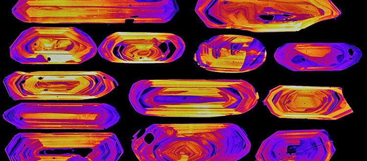
Most active volcanoes on Earth are dormant, meaning that they have not erupted for hundreds or even thousands of years, and are normally not considered hazardous by the local population. A team of volcanologists from the University of Geneva (UNIGE), working in collaboration with the University of Heidelberg in Germany, has devised a technique that can predict the devastating potential of volcanoes. The scientists used zircon, a tiny crystal contained in volcanic rocks, to estimate the volume of magma that could erupted if Nevado de Toluca volcano (Mexico) wakes up from its dormancy. Up to 350 km3 of magma —about four times the volume of water stored in Lake Geneva— are currently lying below Nevado de Toluca and an eruption could bring devastation. The new technique, applicable to most types of volcanoes across the globe, is described in the scientific journal Nature Communications.
The largest volcanic eruptions in the last 100 years were sourced from volcanoes that do not erupt frequently and therefore fly under the radar of scientists. Yet today, 800 million people around the world live close to volcanoes and are potentially at risk. A determining factor for the dangerousness of volcanoes is the volume of eruptible magma stored in their bellies, as this is related to the magnitude of future eruptions. Unfortunately, this magma is stored at inaccessible depths of 6 to 10 km and cannot be directly measured.
The future of disaster management, using artificial intelligence, machine learning, and a bit of Waffle House and Starbucks 🙂
Ira Pastor, ideaXme life sciences ambassador interviews Craig Fugate Chief Emergency Management Officer of One Concern and former administrator of the Federal Emergency Management Agency (FEMA).
The international context of this interview: In choosing our leaders it is becoming increasingly important to select people who can both anticipate and address and where possible avoid large scale disasters. Here, Craig Fugate discusses evaluating past disasters, planning for future events and reacting to the “unexpected” — “think big and move fast”.
Ira Pastor comments:
The U.S. has sustained 279 weather and climate disasters since 1980 where overall damages/costs reached or exceeded $1 billion (including CPI adjustment to 2020). The total cost of these 279 events exceeds $1.825 trillion.
Like its key allies, the UK is increasingly reliant on space-based assets for daily life in ordinary civil society and for the perfornance of its military forces. So, the Royal Air Force’s operating domain now extends from the ground to far beyond the atmosphere.
In a lockdown summer of downbeat aviation news, it is perhaps fitting that a highlight was a model aeroplane in a windtunnel. In turbulent times for aerospace, that aircraft is even named after a storm. But in showing some detail of the external shape of the Tempest future fighter, BAE Systems has also emphasised the UK’s determination to ride out the technological, financial and geopolitical hurricanes which are set to shape the national defence challenges of the next few decades.
Those late August images from BAE’s Warton, Lancashire test facility reveal an external profile designed for stealth at Mach 2, to carry a wide range of payloads and to cope with the internal heat from enough onboard electric power to anticipate exotic technologies like laser directed-energy weapons.
TESS, the Transiting Exoplanet Survey Satellite, was launched in 2018 with the goal of discovering small planets around the Sun’s nearest neighbors, stars bright enough to allow for follow-up characterizations of their planets’ masses and atmospheres. TESS has so far discovered seventeen small planets around eleven nearby stars that are M dwarfs — stars that are smaller than the Sun (less than about 60% of the Sun’s mass) and cooler (surface temperatures less than about 3900 kelvin). In a series of three papers that appeared together this month, astronomers report that one of these planets, TOI-700d, is Earth-sized and also located in its star’s habitable zone; they also discuss its possible climate.
CfA astronomers Joseph Rodriguez, Laura Kreidberg, Karen Collins, Samuel Quinn, Dave Latham, Ryan Cloutier, Jennifer Winters, Jason Eastman, and David Charbonneau were on the teams that studied TOI-700d, one of three small planets orbiting one M dwarf star (its mass is 0.415 solar masses) located one hundred and two light-years from Earth. The TESS data analysis found the tentative sizes of the planets as being approximately Earth-sized, 1.04, 2.65 and 1.14 Earth-radii, respectively, and their orbital periods as 9.98, 16.05, and 37.42 days, respectively.
Extreme events occur in many observable contexts. Nature is a prolific source: rogue water waves surging high above the swell, monsoon rains, wildfire, etc. From climate science to optics, physicists have classified the characteristics of extreme events, extending the notion to their respective domains of expertise. For instance, extreme events can take place in telecommunication data streams. In fiber-optic communications where a vast number of spatio-temporal fluctuations can occur in transoceanic systems, a sudden surge is an extreme event that must be suppressed, as it can potentially alter components associated with the physical layer or disrupt the transmission of private messages.
Recently, extreme events have been observed in quantum cascade lasers, as reported by researchers from Télécom Paris (France) in collaboration with UC Los Angeles (USA) and TU Darmstad (Germany). The giant pulses that characterize these extreme events can contribute the sudden, sharp bursts necessary for communication in neuromorphic systems inspired by the brain’s powerful computational abilities. Based on a quantum cascade laser (QCL) emitting mid-infrared light, the researchers developed a basic optical neuron system operating 10,000× faster than biological neurons. Their report is published in Advanced Photonics.
A 7.5 magnitude earthquake struck off the Alaska Peninsula, triggering a tsunami warning in the region that has since been downgraded to an advisory. CBS Los Angeles has the latest.


