the B612 Foundation made estimates of Apophis path if a 2036 Earth impact were to occur.
The impact result is a narrow corridor called the ‘risk corrider’ which would be a few miles wide. Countries estimated to be in the direct path:
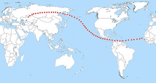
- southern Russia,
- across the north Pacific Ocean (relatively close to the coastlines of the California and Mexico), then
- right between Nicaragua and Costa Rica,
- crossing northern Colombia and
- Venezuela and over the Caribbean islands of Trinidad and Tobago,
- over the Atlantic Ocean to the west coast of Africa.
Earth’s Path of Risk for the 99942 Apophis Asteroid that is suspected to be on track for a collision course with earth in the year 2036. This image is self-made from data estimated by the B612 Foundation, this is why it is just an approximation. Credit: Mario Roberto Duran Ortiz Mariordo and the re-use of this image is based on ‘Fair use’ of public domain info by the B612 Foundation work on Apophis.
The hypothetical impact of Apophis along the path of risk could have more than 10 million casualties, however the threatened zones would be evacuated [as per B612 foundation comment. The threat of casualties would be for a similar sized object, if it was not detected.].
Spaceworks Engineering had an award winning plan to send a spacecraft to shadow the Apophis asteroid
A video Foresight: A Radio Beacon Mission to Asteroid Apophis is on Youtube.
Several comments:
1) For a variety of reasons we have renamed the earlier “path of risk” the “risk corridor”. We would appreciate the use of this in future comments.
2) You use 2036 twice and 2037 once for the potential 1/45,000 impact of Apophis. The date of the potential impact is 2036.. April 13.
3) The Apophis risk corridor is not an approximation; it is accurately plotted (in papers on our website) based on the work of Dr. Dan Scheeres.
4) Your statement about “10+ million casualties” is completely absurd. *If* Apophis is going to hit we’ll know it many years ahead. If it is going to hit in the ocean the adjoining coastlines can be evacuated as little as 1 km inland. If it’s going to hit on land (not likely) an evacuation with years to plan for it should save virtually all lives. Infrastructure and property is quite another matter.
B612 Foundation
Thanks for the information. I have corrected the article.
For those interested in improving NEOs/asteroid detection and tracking, the distributed computing project Orbit@home is now in the beta phase and sending out work units.
This is a software that you can run using idle CPU cycles to crunch scientific data.
The URL is here: http://orbit.psi.edu/
And here’s something I’ve written about distributed computing in general:
http://michaelgr.com/distributed-computing/
Noted in the comment by B612 Foundation that the risk corridor is accurately plotted, however there seems to be some contention to this statement, please see;
http://space.newscientist.com/article/mg19926643.500-killer-asteroid-tracking-may-be-off-by-millions-of-miles.html?DCMP=ILC-hmts&nsref=top1_head_Killer%20asteroid%20predictions%20’off%20by%20millions%20of%20miles’
That link is New Scientist and requires subscription to read all.Shame that some sites have gone “pay per view” like New Scientist has.Also a shame that there are so many hucksters trying to sell “Scientific Papers” online when they are obviously in the public domain, (sorry for the rant).
Thanks for the corrections — I’ll see to it that I change the information.
This is not so much a comment on the above post I’m just raising the question as to whether it is possible that the “big one” is actually in an Earth orbit already. I say “orbit” because my daughter and a few friends saw a large fireball over England on July the 9th and I have seen a similar object several years ago. In both sightings the head of the fireball was black and distending an angle at the eye of about 1 degree at closest approach. Both had orange flames around the head but there were differences. I shall not elaborate at this point but realise the orbit must be highly elliptical and that the upper atmosphere is being periodically grazed if we have indeed seen the same object. I am contacting you because I am concerned. I have a degree in physics/astrophysics. I can supply drawings and I *seem* to be getting help from the local press in asking any other viewers to come forward. If this produces results I can communicate them to you.
I await any response.
Astrophysicists in Russia sounded a forewarning that an asteroid named Apophis could hit the planet in the year 2036. If Apophis defies the odds and hits a “gravitational keyhole” during a 2029 pass, its trajectory might be tweaked into a collision course with Earth in 2036. The odds are so great of that occurring, that NASA isn’t worried about Apophis, but the agency is aware of the urgent need to prevent an asteroid collision.